Context
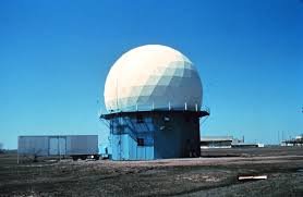
To strengthen weather monitoring under Mission Mausam, Indian Institute of Tropical Meteorology recently commissioned a new X-band Doppler Weather Radar (DWR) at Mahabaleshwar.
About Doppler Weather Radar
- Doppler Radar: It is a specialised radar system that applies the Doppler effect to determine the movement and speed of objects located at a distance.
- Based on the Doppler principle, the radar uses a parabolic dish antenna and a foam sandwich spherical radome to improve the accuracy of long-range weather forecasting and monitoring.
- Located at an altitude of about 1,400 metres in the Western Ghats, the system continuously observes weather conditions like a “weather eye in the sky.”
- It can monitor rainfall, clouds, storms, fog, and strong winds in real time, improving short-term forecasts (up to 3 hours) for regions such as Pune, Satara, Konkan, and Mumbai.
- The radar will help scientists better understand heavy rainfall, monsoon behaviour, and storm activity, especially in hilly regions.
Doppler effect
- When there is relative motion between a source and an observer, the observed frequency changes. The frequency increases when they move closer to each other and decreases when they move apart.
- This change allows the radar to accurately measure the speed of a target moving toward or away from it.
Application
- These radars are useful for studying how clouds form because they can detect very small water droplets and light precipitation such as snow.
- However, X-band radars lose signal strength quickly (attenuate easily), so they are mainly used for short-range weather monitoring.