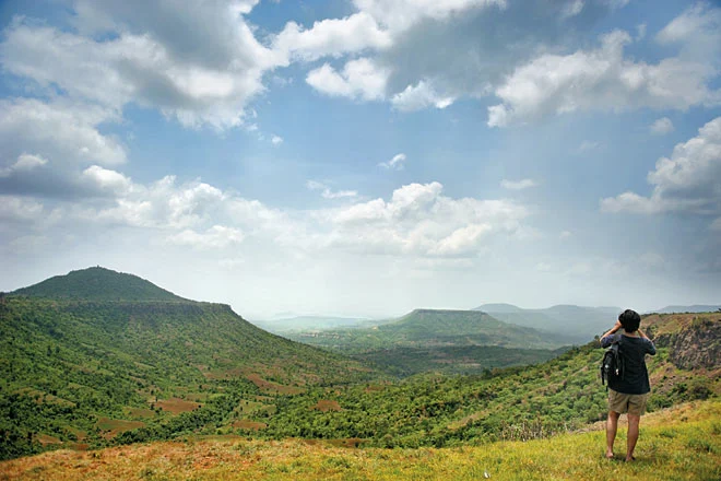
The Malwa Plateau is a prominent volcanic upland in north-central India, primarily encompassing western Madhya Pradesh and extending into southeastern Rajasthan. It serves as a vital bridge between the Vindhya Range and the Indo-Gangetic plains, characterized by its fertile “black cotton soil” and a legacy that dates back to ancient Indian civilizations.
Geographical Features and Boundaries
Formed 60–68 million years ago during the Cretaceous period, the Malwa Plateau is part of the Deccan Traps.
- Elevation & Terrain: The plateau maintains an average elevation of 500–600 meters (1,650 to 2,000 feet) above sea level, with its highest point at Sigar Peak (881 m).
- Soil Composition: The region is covered in rich, moisture-retaining volcanic soil (black, brown, and stony), which is high in iron content and reduces the heavy need for irrigation.
- Boundaries:
- South and East: Bordered by the Vindhya Range.
- North: Transitions into the Madhya Bharat Plateau and Bundelkhand Upland.
- West: Bordered by the Gujarat Plains and the state of Gujarat.
Regional Distribution
The plateau is shared between two primary states, contributing significantly to their respective economies.
1 Madhya Pradesh: Hosts the majority of the plateau. Key districts include Indore, Ujjain, Dewas, Dhar, Jhabua, and Mandsaur.
2 Rajasthan: Covers southeastern districts such as Jhalawar (noted for wheat and cotton), Kota (an industrial hub), Chittorgarh, and Banswara.
Historical Significance
The name “Malwa” is derived from the Sanskrit word malav, meaning “part of the abode of Lakshmi,” the goddess of wealth.
- Ancient Kingdoms: It was a central part of the Avanti kingdom, one of the sixteen Mahajanapadas.
- Ujjain: This historic city was a global center for astronomy, trade, and learning. It remains one of the seven sacred cities of Hinduism.
- Dynastic Rule: Over centuries, the plateau was governed by the Mauryas, Guptas, Paramaras, Delhi Sultanate, Mughals, and Marathas.
River Systems and Hydrology
The plateau’s hydrology is defined by rivers that flow through terraced valleys, supporting both irrigation and local ecosystems.
- Western Drainage: The Mahi River drains the western sections.
- Central & Eastern Drainage: The Chambal River dominates the central region, while the Betwa flows through the east.
- Other Major Rivers: The Shipra (culturally significant in Ujjain), Kali Sindh, Parbati, Gambhir, and Choti Kali Sindh.
- Headwaters: The plateau also hosts the headwaters of the Dhasan and Ken
Climate and Vegetation
Classified as Tropical Wet and Dry (Aw) under the Köppen-Geiger system, the climate is moderated by the plateau’s elevation.
Climate Cycles
- Summers: Hot, with temperatures ranging from 30°C to 45°C.
- Monsoon: Receives 900 mm to 1,200 mm of rainfall, which is the lifeline for local agriculture.
- Winters: Mild, with temperatures between 10°C and 25°C, though nights can drop to 6°C.
Natural Vegetation and Agriculture
- Forests: Dominated by tropical dry deciduous forests, primarily Teak and Sal trees that shed leaves during dry seasons to conserve moisture.
- Undergrowth: Common shrubs include Grewia and Ziziphus, alongside extensive grasslands for livestock.
- Agriculture: The fertile black soil supports wheat, rice, pulses, and oilseeds. Key cash crops include cotton and sugarcane.
Frequently Asked Questions (FAQs)
WHICH STATES COVER THE MALWA PLATEAU?
The plateau primarily covers western Madhya Pradesh and southeastern Rajasthan.
WHAT IS THE HIGHEST PEAK OF THE MALWA PLATEAU?
Sigar Peak, standing at 881 meters, is the highest point on the plateau.
WHICH RIVER IS CULTURALLY SIGNIFICANT ON THIS PLATEAU?
The Shipra River, which flows through the sacred city of Ujjain, holds immense cultural and religious significance.
HOW WAS THE MALWA PLATEAU FORMED?
It was formed 60–68 million years ago from volcanic lava flows known as the Deccan Traps.
WHAT TYPE OF SOIL IS FOUND IN THIS REGION?
The region is famous for its black, brown, and stony volcanic soil, which is rich in iron and highly moisture-retentive.
WHAT ARE THE MAIN CROPS GROWN ON THE MALWA PLATEAU?
Major crops include wheat, rice, pulses, and oilseeds, while cotton and sugarcane are the primary cash crops.
WHICH ANCIENT KINGDOM WAS LOCATED HERE?
The Avanti kingdom, one of the sixteen Mahajanapadas of ancient India, was centered on this plateau.
WHAT TYPE OF FORESTS ARE FOUND IN MALWA?
The region features tropical dry deciduous forests, with Teak and Sal being the dominant tree species.
WHICH MOUNTAIN RANGE BORDERS THE PLATEAU TO THE SOUTH?
The Vindhya Range forms the southern and eastern borders of the Malwa Plateau.
WHAT IS THE AVERAGE RAINFALL ON THE PLATEAU?
The region receives an average annual monsoon rainfall of 900 mm to 1,200 mm.