| Important questions for UPSC Pre/ Mains/ Interview:
1. What is the Great Nicobar Infrastructure Project? 2. Where is Great Nicobar located and why is it strategically important? 3. What are the four core components of the project? 4. What is the environmental footprint of the project? 5. How does the project strengthen India’s maritime and defence posture? 6. What ecological concerns arise from the project? 7. What are the social and tribal governance concerns? 8. What governance and legal issues are involved? 9. What are the strategic and economic benefits? 10.What are the major environmental and socio-political risks? 11.What safeguards and oversight mechanisms are necessary? |
Context
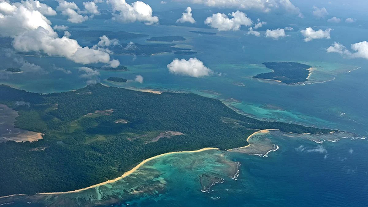
The National Green Tribunal (NGT) has approved the ₹81,000-crore Great Nicobar infrastructure project, citing strategic necessity and environmental safeguards. The 166 sq km mega project aims to transform Great Nicobar Island into a strategic and economic hub in the Indo-Pacific, but involves large-scale forest diversion and ecological intervention.
Q1. What is the Great Nicobar Infrastructure Project?
- A large-scale integrated development initiative on Great Nicobar Island.
- Total project area: 166 sq km.
- Estimated cost: ₹81,000 crore.
- Forest diversion: About 130 sq km.
- Nearly one million trees proposed to be felled.
- Implemented by Andaman and Nicobar Islands Integrated Development Corporation Ltd (ANIIDCO).
Q2. Where is Great Nicobar located and why is it strategically important?
- Southernmost island of India.
- Hosts Indira Point.
- Located close to the Malacca Strait.
- Approximately 94,000 ships pass annually through the Strait.
- Accounts for nearly 30% of global traded goods and one-third of maritime oil trade.
Its location offers strategic leverage in Indo-Pacific maritime dynamics.
Q3. What are the four core components of the project?
- What is planned under the integrated township?
- Area: Around 149 sq km.
- Residential, commercial, tourism, logistics facilities.
- Defence infrastructure included.
- Designed for long-term economic and strategic expansion.
- What is the transshipment port proposal?
- Location: Galathea Bay (southern tip).
- Purpose: Transfer cargo from large vessels to smaller ships.
- Planned capacity: 14.2 million TEUs annually.
- Land reclamation: 2.98 sq km.
- Intended to compete with:
- Colombo
- Hambantota
- Port Klang
- Singapore
- What is the civil-military airport component?
- Dual-use international airport.
- Located east of the port.
- Second air facility after INS Baaz.
- Land required: 4.2 sq km.
- Impacts approximately 379 families.
- What is the proposed power infrastructure?
- 450 MVA gas and solar-based power plant.
- Area: 0.39 sq km.
- Ensures energy security for township and defence facilities.
Q4. What is the environmental footprint of the project?
- Forest diversion: 130 sq km.
- Nearly one million trees to be felled.
- Land reclamation for infrastructure.
- Construction material requirement: 33.35 million cubic metres.
- Large-scale intervention in fragile island ecosystem.
Q5. How does the project strengthen India’s maritime and defence posture?
- Enhances monitoring of Indo-Pacific shipping lanes.
- Strengthens role of Andaman and Nicobar Command (India’s tri-services command).
- Integrates civil and military logistics infrastructure.
- Supports maritime domain awareness.
- Provides forward operating base capability.
Q6. What ecological concerns arise from the project?
- Why is biodiversity at risk?
- Island falls under Great Nicobar Biosphere Reserve.
- Part of Sundaland biodiversity hotspot.
- Includes littoral forests, evergreen hill forests, coastal wetlands.
- What wildlife habitats are affected?
- Denotification of Galathea Bay Wildlife Sanctuary.
- Impact on nesting site of leatherback turtles.
- Threat to endemic Nicobar megapode.
- How might land reclamation affect marine ecology?
- Alteration of coastal geomorphology.
- Disturbance to coral ecosystems.
- Potential sedimentation impact.
Q7. What are the social and tribal governance concerns?
- How does it affect the Shompen tribe?
- Semi-nomadic, forest-dwelling indigenous community (~250 people).
- Highly vulnerable to external exposure.
- Risk of cultural and health disruption.
- What concerns are raised by the Nicobarese community?
- Many displaced post-2004 tsunami.
- Pending rehabilitation demands.
- Fears of demographic and land-use transformation.
- What is the demographic implication?
- Current population: ~8,500.
- Projected population by 2050: 6.5 lakh.
- Risk of ecological and cultural imbalance.
Q8. What governance and legal issues are involved?
- Forest diversion requires statutory clearances.
- Environmental Impact Assessment (EIA) conducted.
- NGT approval sets precedent for strategic projects.
- Involves coordination between:
- Ministry of Environment
- NITI Aayog
- Andaman & Nicobar Administration
- Defence Ministry
- Balancing national security and environmental conservation.
Q9. What are the strategic and economic benefits?
- Enhances maritime logistics capacity.
- Reduces reliance on foreign transshipment ports.
- Strengthens Indo-Pacific geopolitical positioning.
- Expands defence readiness.
- Promotes long-term economic activity.
Q10. What are the major environmental and socio-political risks?
- Permanent loss of primary forests.
- Habitat fragmentation.
- Threat to endangered species.
- Risk of tribal marginalisation.
- Potential climate vulnerability due to sea-level rise.
Q11. What safeguards and oversight mechanisms are necessary?
- Strict environmental monitoring.
- Biodiversity conservation zones with buffer safeguards.
- Independent ecological audits.
- Protection protocols for tribal communities.
- Phased development aligned with carrying capacity assessments.
Conclusion
The Great Nicobar Infrastructure Project represents a high-stakes convergence of strategic ambition and ecological sensitivity. While it enhances India’s maritime posture and economic potential, it raises profound environmental and tribal rights concerns. Sustainable implementation will require careful ecological stewardship, institutional oversight, and constitutional sensitivity to indigenous and environmental protections.