- Courses
- GS Full Course 1 Year
- GS Full Course 2 Year
- GS Full Course 3 Year
- GS Full Course Till Selection
- Online Program
- GS Recorded Course
- NCERT (Recorded 500+ Hours)
- Polity Recorded Course
- Geography Recorded Course
- Economy Recorded Course
- AMAC Recorded Course
- Modern India, Post Independence & World History
- Environment Recoded Course
- Governance Recoded Course
- Science & Tech. Recoded Course
- International Relations and Internal Security Recorded Course
- Disaster Management Module Course
- Ethics Recoded Course
- Essay Recoded Course
- Current Affairs Recoded Course
- CSAT
- 5 LAYERED ARJUNA Mentorship
- Public Administration Optional
- ABOUT US
- OUR TOPPERS
- TEST SERIES
- FREE STUDY MATERIAL
- VIDEOS
- CONTACT US
PLACES IN NEWS 27th FEBRUARY 2025
PLACES IN NEWS 27th FEBRUARY 2025
27-02-2025

Kaziranga National Park
Why in news?
- India's External Affairs Minister and envoys from 61 countries recently explored Kaziranga National Park, enjoying elephant and jeep safaris to experience its rich biodiversity and iconic one-horned rhinos.
About Kaziranga National Park:
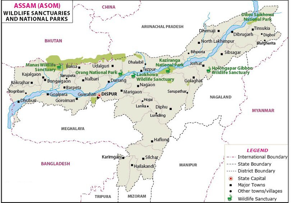
- Location:
- Kaziranga National Park is located in the northeastern state of Assam, India.
- It is the largest undisturbed area representing the Brahmaputra Valley floodplain ecosystem.
- The park was designated a UNESCO World Heritage Site in 1985 for its unique biodiversity and conservation efforts.
- The Brahmaputra River flows through the national park.
- Flora and Fauna:
- The park’s vegetation consists of tall elephant grasses, dense forests, rugged reeds, and marshlands, providing an ideal habitat for wildlife.
- The wetland areas are covered with water lilies, water hyacinths, and lotus, enriching the aquatic ecosystem.
- Kaziranga is home to many endangered and threatened species, including the Indian one-horned rhinoceros, Bengal tiger, Asiatic elephant, Eastern swamp deer, and wild buffalo.
- Other significant species include the Hoolock gibbon, Capped langur, and Gangetic River dolphin, making it one of the most biodiverse regions in India.
- The park harbours the largest population of one-horned rhinoceroses in the world, contributing significantly to their conservation.
- Significance:
- Kaziranga National Park plays a vital role in wildlife conservation and is a key site under Project Tiger and Project Rhino.
- The park’s unique landscape and rich biodiversity make it a major tourist attraction and a symbol of India’s commitment to wildlife protection.
Godavari River
Why in news?
- During a tragic incident, five people drowned in the Godavari River in Andhra Pradesh.
About Godavari River:
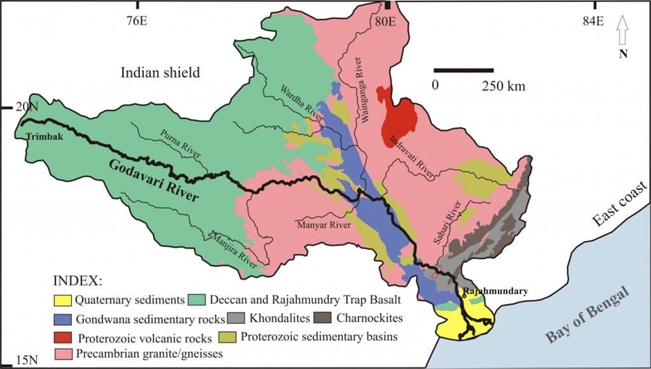
- Origin:
- The Godavari River, known as the Dakshina Ganga (the Ganges of the South), is India’s second-longest river after the Ganga.
- It originates from the Brahmagiri Mountain at Trimbakeshwar in Nashik district, Maharashtra, and flows for approximately 1,465 kilometres.
- The river traverses Maharashtra, Telangana, and Andhra Pradesh, while its basin extends into Madhya Pradesh, Karnataka, Chhattisgarh, and Odisha.
- It finally drains into the Bay of Bengal near Narasapuram in West Godavari district, Andhra Pradesh.
- The river receives maximum rainfall during the Southwest monsoon, significantly influencing its flow.
- The Godavari River's major tributaries include Pravara, Purna, Manjra, Penganga, Wardha, Wainganga, Pranhita, Indravati, Maner, and Sabri, supporting irrigation, hydroelectric projects, and biodiversity.
- Economic Significance:
- The Godavari River is crucial for irrigation, hydroelectric power generation, and water supply across multiple states.
- Major irrigation projects on the river include:
- Polavaram Project (Andhra Pradesh)—A multipurpose project for irrigation, hydroelectricity, and drinking water.
- Jayakwadi Dam (Maharashtra) – One of the largest earthen dams for irrigation.
- Sriram Sagar Project (Telangana) – Supplies water to Telangana and Maharashtra.
- Dowleswaram Barrage (Andhra Pradesh) – Essential for delta irrigation.
- Historical and Cultural Significance:
- The Godavari River holds deep spiritual and religious importance in Hinduism.
- The city of Nasik, on its banks, hosts the Kumbh Mela, which is one of Hinduism’s largest religious gatherings.
- Several ancient temples, including Trimbakeshwar Jyotirlinga, Bhadrachalam Temple, and Kaleshwaram Temple, are located along its course.
- The river is frequently mentioned in Hindu scriptures like the Ramayana and Mahabharata, as Lord Rama is believed to have spent time near its banks during his exile.
- Ecological Significance:
- The Godavari basin harbours rich biodiversity, including mangroves, wetlands, and various aquatic species.
- Notable protected areas along the river include Papikonda National Park and Kolleru Lake Bird Sanctuary.
- The river sustains wetland ecosystems supporting migratory birds and freshwater fish species.
- However, deforestation, pollution, and excessive damming pose significant threats to the river's ecological balance.
Vembanad Lake
Why in news?
- The Nerekadavu-Makkekadavu bridge is under construction across Vembanad Lake, enhancing connectivity and regional development.
About Vembanad Lake:
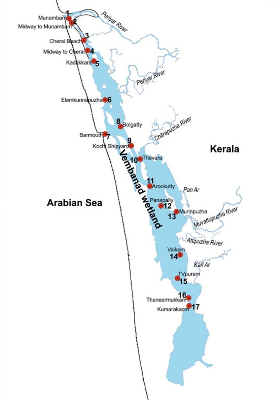
1. Location:
- Vembanad Lake is the largest lake in Kerala and the longest lake in India.
- It stretches across multiple districts of Kerala, including Alappuzha, Kottayam, and Ernakulam.
- The lake is also known by different names in various regions: Vembanad Kayal, Vembanad Kol, Punnamada Lake (in Kuttanad), and Kochi Lake (in Kochi).
- It is separated from the Arabian Sea by a narrow barrier island and forms an essential part of Kerala’s backwater ecosystem.
- The lake receives water from four major rivers—Meenachil, Attipuzha, Periyar, and Manimala.
- These rivers contribute to the lake’s freshwater inflow, making it a dynamic brackish water ecosystem.
2. Economic Benefits:
- Vembanad Lake is a hub for fishing, tourism, and inland water transport, providing livelihoods to thousands.
- It is famous for houseboat tourism, attracting domestic and international visitors.
- The Nehru Trophy Boat Race (Vallam Kali), a major cultural and sporting event, is held every August on the lake.
- The lake supports paddy cultivation in Kuttanad, known as the “Rice Bowl of Kerala,” through its irrigation network.
3. Ecological Significance:
- In 2002, Vembanad Lake was designated a Ramsar Wetland of international importance.
- The Kumarakom Bird Sanctuary, located on the eastern shores, is home to migratory birds like Siberian cranes and herons.
- The lake plays a crucial role in flood control, groundwater recharge, and biodiversity conservation, supporting mangroves, fish species, and aquatic plants.
Haiti
Why in news?
- Haiti's capital, Port-au-Prince, faces escalating violence as armed gangs expand control, overwhelming security forces. The crisis has intensified political instability, displacing thousands and worsening humanitarian conditions in the region.
About Haiti:
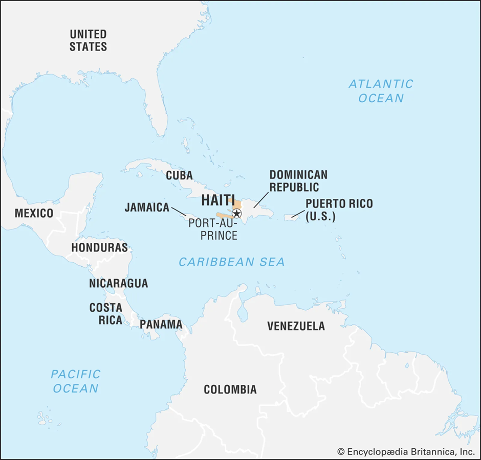
- Location and Geography:
- Haiti is a Caribbean nation located on the western part of Hispaniola Island, which it shares with the Dominican Republic.
- It is the third-largest country in the Caribbean, with a mountainous terrain and a tropical climate.
- Haiti is bordered by the Atlantic Ocean to the north, the Caribbean Sea to the south, and the Windward Passage to the west, separating it from Cuba.
- Its capital, Port-au-Prince, is the country’s largest city and the centre of political and economic activities.
- The country is prone to natural disasters, including hurricanes, earthquakes, and floods, which have severely impacted its development.
- Origin of Gang Violence and Causes:
- Gang violence in Haiti has deep historical roots, linked to political instability, economic struggles, and weak governance.
- The problem intensified after the 2010 earthquake, which devastated infrastructure and left many unemployed, increasing gang recruitment.
- Political voids created by weak leadership, especially after the assassination of President Jovenel Moïse in 2021, have fuelled gang expansion.
- Armed groups control large parts of Port-au-Prince, engaging in extortion, kidnappings, and drug trafficking.
- Foreign arms smuggling, mainly from the U.S., has increased the firepower of gangs, worsening the security situation.
- Economic hardships, high unemployment rates, and poverty have led many youths to join gangs for survival.
- Humanitarian Crisis:
- Ongoing gang violence in Haiti has displaced hundreds of thousands, forcing them to flee their homes and creating a severe internal refugee crisis.
- Food and medical shortages have become critical, as gang blockades have disrupted supply chains, preventing essential goods from reaching affected populations. Many hospitals have shut down due to violence, leaving people without access to healthcare amid increasing casualties.
- The country is experiencing widespread insecurity, with a surge in kidnappings, sexual violence, and targeted killings.
- The political situation remains paralysed, with the government unable to restore order, leading to rising anarchy and a loss of public confidence.
- As conditions deteriorate, Haiti’s crisis is spilling over into neighbouring countries, with thousands fleeing to the Dominican Republic and the U.S., escalating regional migration challenges.
Lake Chad
Why in news?
- Chad recently completed Operation Haskanite in the Lake Chad region, targeting Boko Haram strongholds to enhance security in the area.
About Lake Chad:
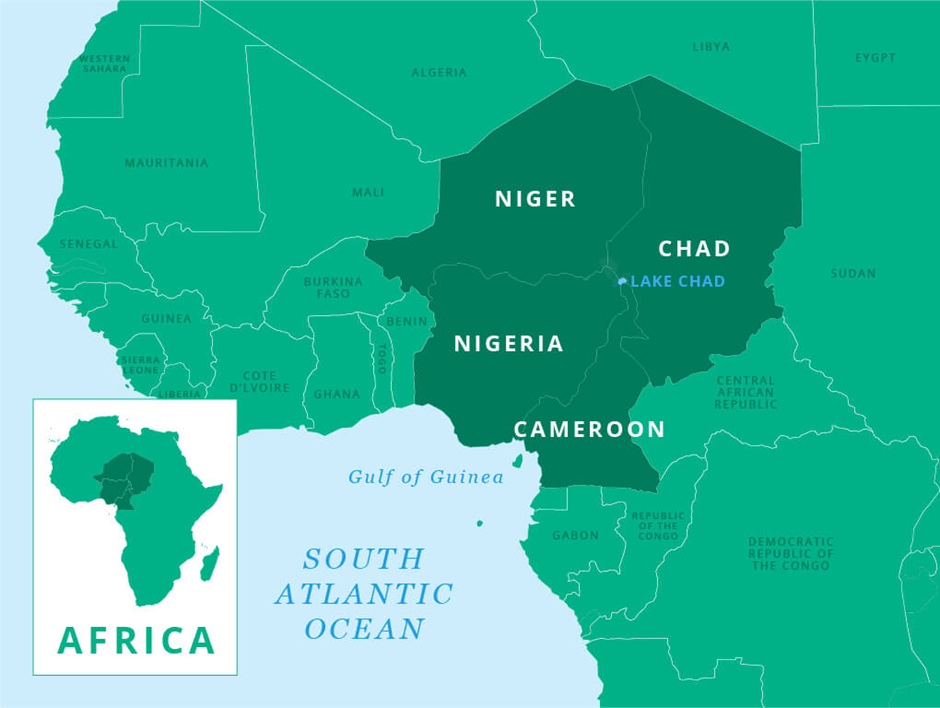
- Location:
- Lake Chad is a shallow, endorheic lake (closed drainage basin lake) located in Central Africa, shared by Chad, Cameroon, Niger, and Nigeria.
- It is part of the Chad Basin and has historically been one of the largest freshwater lakes in Africa.
- The lake has significantly shrunk due to climate change, unsustainable water use, and desertification.
- It serves as a critical water source for over 30 million people across the four bordering countries.
- Economic Significance:
- The lake supports fishing, farming, and livestock rearing, providing livelihoods to millions.
- It has rich natural resources, including oil, gas, and uranium deposits, attracting interest in energy production.
- The region is crucial for agriculture, as seasonal floods enrich the soil, supporting crops like millet and sorghum.
- Sustainable development projects, such as water conservation and irrigation initiatives, aim to revive the lake’s declining water levels.
- Ecological Significance:
- Lake Chad is home to diverse flora and fauna, including migratory birds, fish species, and wetland ecosystems.
- It plays a vital role in regional climate regulation, mitigating the effects of desertification in the Sahel.
- The lake’s shrinking size has increased conflict over water resources, which impacts human and ecological stability.
- Boko Haram Insurgency and Operation Haskanite
- Boko Haram, an extremist group, has been active in the Lake Chad region since the early 2000s.
- The insurgency has led to thousands of deaths and millions displaced, severely affecting local communities.
- The group has targeted villages, security forces, and humanitarian aid operations, worsening instability.
- The loss of livelihoods and limited state presence have enabled Boko Haram to expand its influence in the region.
- In 2024, Chad launched Operation Haskanite to eliminate Boko Haram strongholds in the Lake Chad Basin.
- The military operation aimed to restore security, dismantle terrorist camps, and protect civilian populations.
- It resulted in the neutralisation of several insurgents and the recovery of weapons and equipment.
- The operation is part of broader regional efforts, including the Multinational Joint Task Force (MNJTF), comprising Chad, Nigeria, Niger, Cameroon, and Benin, to combat extremism in the area.

Operation Sindoor to Ceasefire: A Holistic Coverage

RIMES 4th Ministerial Conference 2025 & India’s Role

Sample Registration System (SRS) Report 2021 : India’s Progress in Maternal and Child Health
Karol Bagh Metro Pillar No. 112, Above Domino's, 22B, First Floor, New Delhi - 110060
Copyright © 2024-2026 ENSURE IAS. All rights reserved.